
The Blue Necklace
From the Winter 2024 Issue
Downtown design calls for a water focus
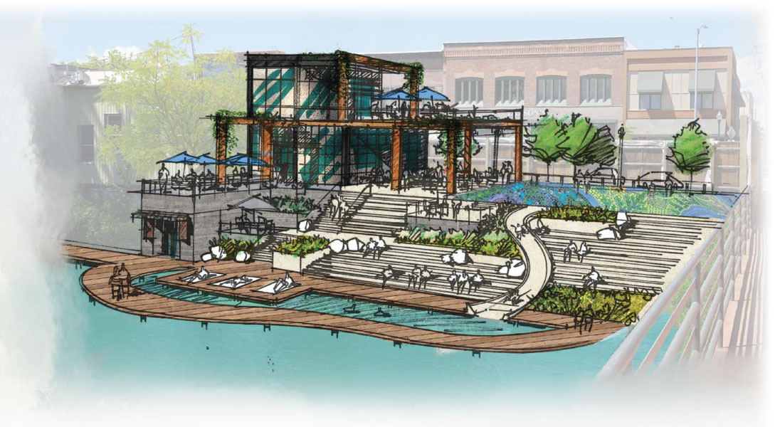
PUBLIC PLAZA DUBBED THE CEDAR STREET TERRACE WAS DESIGNED IN CONJUNCTION WITH CURRENT PRIVATE PROPERTY OWNERS WHO ARE OPEN TO PROVIDING PUBLIC SPACE IN THE LOCATION
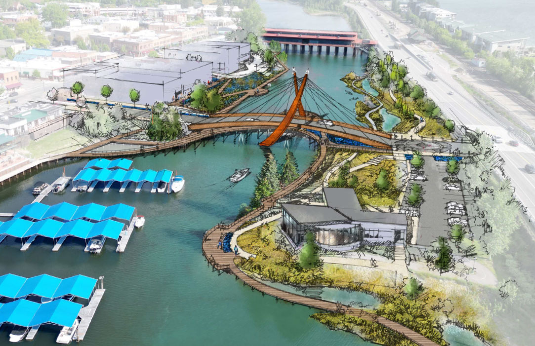
The drive across the Long Bridge, with its 1.76 mile expanse of water to cross on the approach to Sandpoint, offers a promise about our town that’s never been quite fulfilled, as once the traveler reaches town, the water disappears. Sandpoint has never managed to actively embrace its spectacular waterfront outside of a massive community effort to build City Beach. Only Scott Glickenhaus had the vision to recognize the opportunity provided by Sand Creek’s meander behind First Avenue, building a structure in the ’80s—the Cedar Street Bridge—that spanned it and welcomed the water into the downtown core. Though a walking path was built on its eastern side when the bypass was built, the view to the west highlights the neglected service and delivery entrances of downtown commercial buildings. Sandpoint literally turned its back on the water.
That may change, with an ambitious, 20-year downtown design project that seeks to embrace the water in a concept called “the blue necklace,” presented by GGLO+Bernardo Wills, winners of Sandpoint’s recent design competition that sought input on development in downtown.
The plan (Don Stastny, a design planner who oversaw the project, said it’s more of a framework than a plan) covers a wide variety of projects that could transform the downtown experience, ranging from improvements to make Sand Creek an integral part of the town to ideas regarding workforce housing. It also addresses many of the community’s concerns about the preservation and use of downtown spaces, from an expansion of the historic district, to increased parking, to the construction of new buildings and how they fit into the current architectural landscape.
Some highlights from the report include:
- A visual iteration of the blue necklace concept by utilizing camas flowers in the spring and blue lighting (as is used on the byway near the southern entrance to town) to mark a path from City Beach, down Sand Creek, and out to the Granary District via Farmin Park.
- Expanded downtown parking to include a parking structure at the current site of the city parking lot.
- Native plantings throughout Sand Creek to support the riparian ecosystem while reducing “mud flats” during times of low water levels.
- Replacing expansive lawn areas at City Beach (which attract numerous geese) with native plantings that honor the original nature of the area while still allowing for a variety of public uses.
- Placement of the Carousel of Smiles project on the southeast entrance to City Beach, where the Lakeside Motel once stood.
- Improved bicycle and pedestrian access from the Granary District all the way to City Beach, offering children a safer way to reach this desired amenity.
- Creating an event corridor along Oak/Main streets that allows for further expansion of downtown events like Farmers’ Market and the Arts and Crafts Fair, and further tying Farmin Park to both Sand Creek and to the Granary District.
- Expanding the current boundaries of the downtown historic district, and drafting design guidelines for developers to meet (including height limits) when constructing new buildings or renovating older ones that ensure the continuity of architecture downtown.
- In a public/private partnership, the construction of a new public plaza facing Sand Creek, stretching from the Cedar Street Bridge down First Avenue.
- Increasing year-round use of the waterfront with amenities such as an ice ribbon for skating at City Beach, and the ability for light shows along Sand Creek.
The written plan proposal, expansive in its visioning, nonetheless incorporates solutions to many ongoing concerns in the community about growth downtown, including a call for the city to develop codes or processes that require new construction in the core to “preserve the stately character” of existing building structures and “ensure new development is in keeping with the character and identity that has been built here over the decades.” It tackles current design proposals on private property, and offers recommendations for design adjustments more in keeping with the proposed downtown city plan.
It also offers visioning ideas for the Shakapaw building site (formerly Petal Talk) on Cedar Street, the parking garage at the city parking lot, and suggestions for the hotel slated to replace the Edgewater. Along with the potential parking garage, these proposed private property developments will likely have an oversized impact on how downtown looks in the future. The city’s input into the process, it was emphasized, must be determined sooner rather than later.
In conjunction with the city’s multimodal plan, design recommendations also focus on traffic flow through town, suggesting a roundabout at the junction of Superior and First Avenue (discouraging non-essential through truck traffic from moving through the downtown core), incorporating a pedestrian-only zone at the entrance to Bridge Street, re-routing traffic down Pine Street, and, in what’s sure to be a community-pleaser, suggesting the city re-think the Couplet plan that would route truck traffic along the current bike path. It also offers suggestions on the replacement of the bridge crossing Sand Creek on Bridge Street, which is now failing, though that project is still over ten years out.
City council is expected to accept and adopt this plan as a framework as this issue goes to press, though they made clear as it was presented to them that many changes are likely to be made. Some particular areas of concern for council members, where they anticipated more work to be done, included parking and boat parking at City Beach, location of the parking structure, possible rerouting of the Bridge Street bridge and what it will look like, and stormwater management. Given the proposed developments already in the works along most of the 200 block of First Avenue (from Zero Point next to the Panida all the way to the current large “holes in the ground” at First and Bridge, where buildings were destroyed by fire), council indicated they want design guidelines in place as soon as possible (to include height restrictions); interest was also expressed in accepting the location for the Carousel of Smiles on the Sand Creek side of the entrance to City Beach to enable that project, which has potential funders, to move forward.
A chastened city council, surprised by community backlash to planned improvements at Travers Park, emphasized the need for full public involvement in determining details as the plan moves forward.
Gills, in his presentation to the city, pointed out “By no means are we going from this plan to implementation today.” If accepted by council, that’s when the real work will begin.
The full report on proposed changes is available at www.sptmag.com/downtowndesign. You can follow the plan’s progress on the city’s website, or on Facebook at #CityofSandpoint.

Leave a comment