
A Multimodal Curve
From the Summer 2023 Issue
An expansive plan for Sandpoint's streets
In 2021, not long after communities went into lockdown due to the COVID pandemic, the city of Sandpoint adopted a multimodal transportation plan to provide an overarching guide to the development of city streets. A major consideration was routing traffic through town in the safest and most efficient way possible, while also allowing for and improving the bike paths and sidewalks residents have clamored for for decades.
The plan envisions changes that may be 20 years or more out. It is the very definition of “long term.”
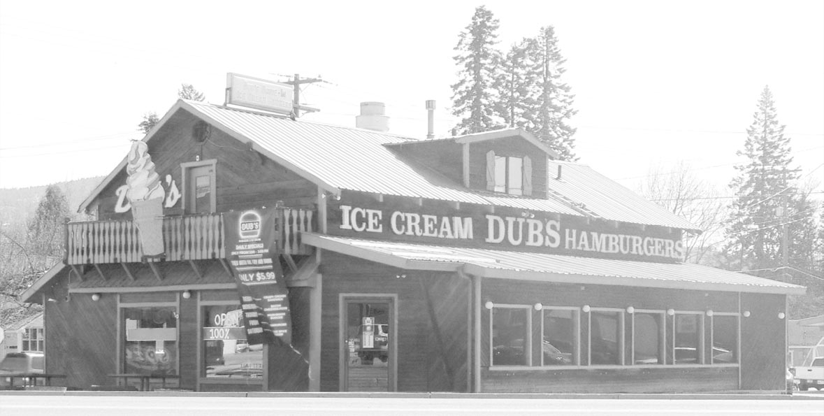
In early 2023, the owners of Dub’s Drive-in, located on the corner of Highway 2 and Boyer Avenue, asked the city to buy their property. Marty and Jeralyn Mire were retiring and younger family members were going to take over running the restaurant. And they were willing to look for a new location to move it to, provided the city would agree to give them time to do so.
The location is a critical component in that multimodal plan, which hopes to bring southbound Fifth Avenue traffic looking to head west along a couplet connecting it to Highway 2 near Dub’s; the city jumped on the deal. And residents—many of whom thought the connecting corridor, called “the Curve” when initially proposed decades earlier, was a dead issue—went wild.
Often lost in the furor is the fact that the multimodal plan is not set in stone: like Captain Barbossa said of the pirate’s code, “It’s more like guidelines than actual rules.” Most of the plan’s projects—like the couplet—are currently unfunded and actual construction may be decades away. The city is now actively seeking people to participate in refining the plan to meet the community’s needs, via open houses, city surveys, public workshops, and more.
THAT CONTROVERSIAL COUPLET
From a traffic standpoint, Sandpoint is a complicated town; in the beginning there was no master plan, so state highways, city streets, walkways, and train tracks multiplied around and over a number of existing waterways wherever they seemed suitable at the time. In this current age of massive trucks, increased train traffic, and a growth in popularity putting ever more vehicles, people, skaters, walkers, and bicyclists on our city streets, “there will be no perfect solutions,” said the city’s outgoing Director of Infrastructure and Development Amanda Wilson. “But [city officials and members of the public] have developed a plan that tries to best meet the needs of all those users in as safe a manner as possible.”
One of the biggest changes to existing traffic flow in the plan involves the city’s through traffic. The completion of the Sand Creek Byway did much to alleviate the problem of Highway 95 traffic traveling north and south from clogging downtown streets. Still unaddressed, however, is traffic utilizing Highway 2 in both directions through town, with either origination or destination at points west. In order to avoid the downtown area, many of those vehicles end up using residential streets—with Division Street of special concern—as a connector between highways 2 and 95. It’s a less than ideal choice, given that Division is home to the high school, the middle school, Farmin Stidwell Elementary, and the schools’ associated traffic, including hundreds of walkers from grades kindergarten through 12.
“[It] causes ‘cut-through’ traffic on residential streets of south Sandpoint that were not designed for such volumes or loads, resulting in safety concerns for pedestrians and bicyclists, as well as accelerating wear and tear on the infrastructure,” reads the Multimodal Master Plan report prepared for city officials in May 2021.
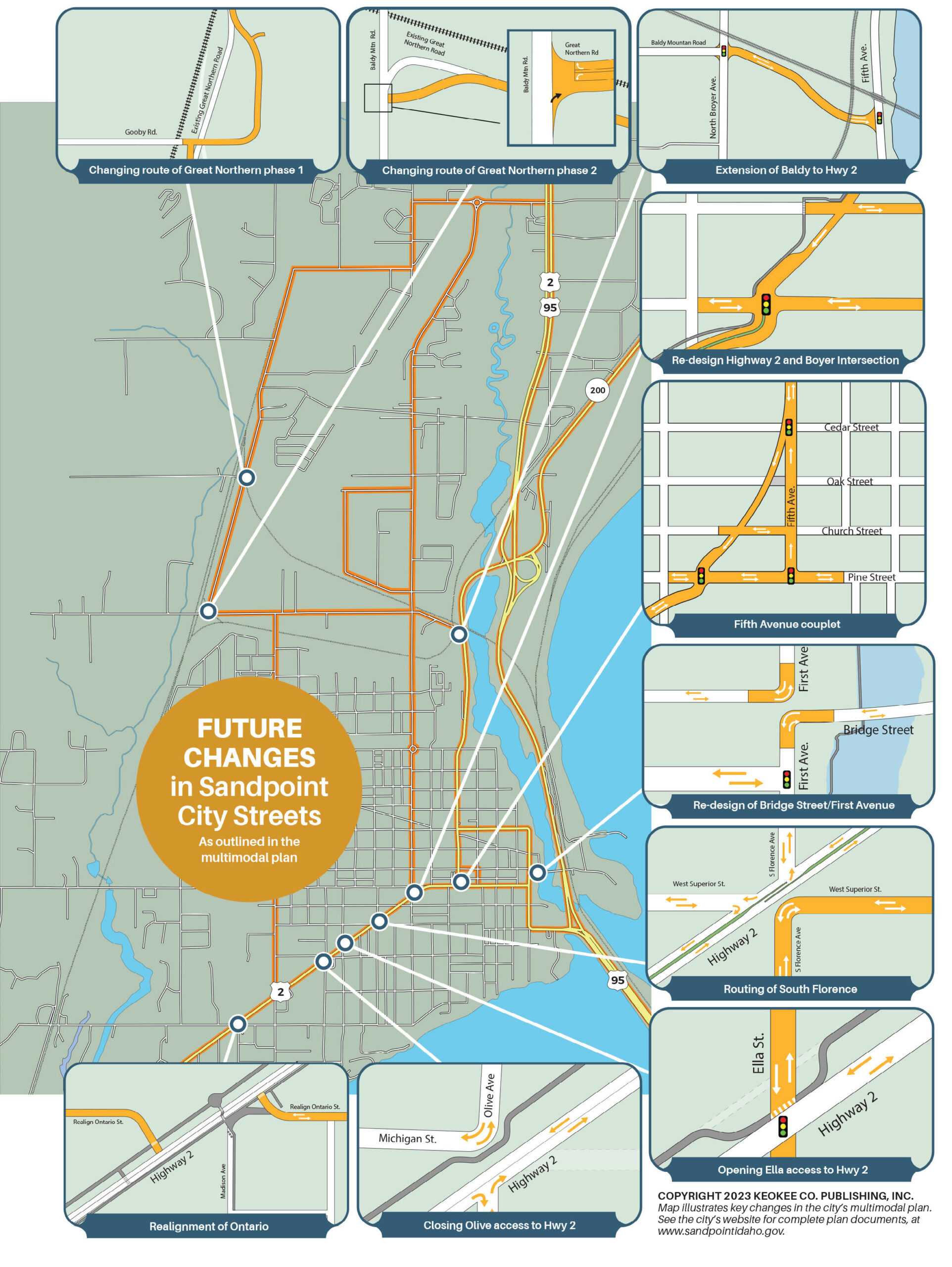
The current official Highway 2 route moves traffic from the west into downtown, where it turns and utilizes Fifth Avenue (owned by the state highway department, not the city) to connect with points north and east. The initial plan would have cut through many local businesses with a five-lane highway via the so-called Curve, which followed a former railroad track that was removed in the 1980s and is now part of the bike path through town.
THE COUPLET, WHEN BUILT, WILL RUN ALONGSIDE THE CURRENT BIKE PATH THROUGH THE GRANARY DISTRICT. PHOTO BY WOODS WHEATCROFT.
The couplet concept was born back in 2012 to avoid those five lanes by separating them in half. It will connect Highway 2 to Fifth and Cedar with two travel lanes going west, allowing traffic moving south along Fifth Avenue to connect with the highway near Dub’s, following that old railroad track. Traffic coming from the west and heading north will still follow Highway 2 to Fifth Avenue, where it will turn left on what will become a one-way street going north as far as the junction with Cedar Street. In the current couplet plan (the one adopted in 2021 and agreed to by ITD) Pine Street from Fifth Avenue to First will become a two-way street, and the traffic light currently at Church and Fifth will move to Pine and Fifth.
At least, that’s the plan. But it’s important to keep in mind that, “This is [Idaho Transportation Department’s] highway—it’s their jurisdiction, and ultimately, they’re going to determine what the highway looks like,” Sandpoint Mayor Shelby Rognstad told the KRFY Morning Show.
With an engineering cost of $3 million to ITD, city and state officials have worked to ensure the couplet’s impact to pedestrians and town cohesion is as minimal as possible. Exactly when it will happen is up to ITD, but it is not a priority for the city.
With the acquisition of the Dub’s property, city staff sought to incorporate adjustments to the proposed couplet—in particular, a restructuring of the Boyer/Highway 2 intersection. After public uproar over its potentially huge size, staff have taken those adjustments off the agenda. “Our focus now is on the minor improvements we can accomplish to improve safety,” said Stapleton. “When ITD is ready to make changes to the highway [and build the couplet] we’ll address those other concerns.
“It’s important to note,” she added, “that every one of the plans [developed by the city] has been 100 percent driven by community concerns.”
CHANGES TO BALDY AND GREAT NORTHERN
Also critical to the plan is a proposed connector extending Baldy Mountain Road at the Boyer Avenue intersection to connect with Fifth Avenue/Highway 2. The new road will intersect with Fifth near where the train overpass crosses the road and adjacent to the Sandpoint Chamber’s visitor center. Work has already begun to lower the grade of the highway where it passes under the train bridge, which is expected to be completed this summer. That work, a state highway project, will allow oversize trucks to travel on Fifth Avenue through town. Currently, they utilize other residential roads to pass through the area as they can’t fit under the train bridge. A signal light will be installed at the new intersection of Boyer and Baldy.
Another important piece of the puzzle involves changes to Great Northern Road. A key street for Sandpoint’s industrial zones, Great Northern suffers from just about every problem a road can have, from soil to safety issues. The plan proposes a reconstruction that seeks to solve or alleviate all these problems.
The first phase includes restructuring Great Northern from the intersection with Gooby Road all the way to Woodland. This portion is already funded, and construction is slated to begin in spring 2025, though preliminary engineering work has already started. The second phase includes moving the intersection of Great Northern and Baldy to the east of where it is now located.
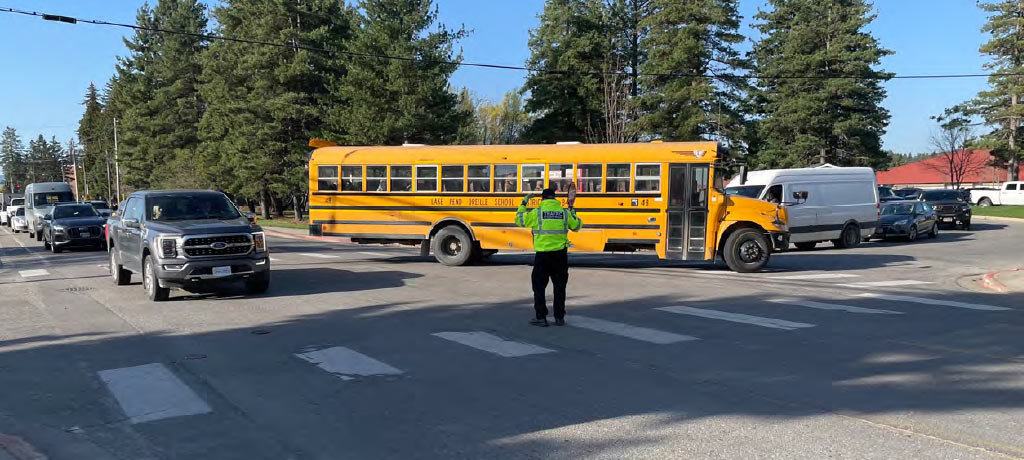
SCHOOL TRAFFIC ON DIVISION AVE.
CHANGES TO DIVISION
The plan calls for two lanes (one in each direction) that include a 6–foot buffer and 6–foot sidewalk on the east, and on the west an 8–foot planter strip (to allow snow storage from the streets) and a 12–foot shared use path to help students move safely along the road.
INTO THE FUTURE
Longer term plans include other major changes to the way traffic moves through town.
The famously frustrating double intersection of Bridge and Church streets on First Avenue frequently creates delays and headaches given the volume of pedestrians and vehicles trying to access City Beach. While the multimodal plan proposes restricting left turns from Bridge to First seasonally, the long-term solution reimagines First between Church and Bridge as a pedestrian- and bicycle-only zone, working in tandem with the other proposed traffic flow revisions.
MAP OF PROPOSED CHANGES. CLICK TO ENLARGE.
“This will help reduce the vehicle delay at both intersections by eliminating stop signs and reducing the amount of pedestrian and vehicle conflicts,” the report reads. But, as depicted in the plan, vehicular traffic would be blocked and unable to travel north or south on First Avenue past that double intersection.
More control over traffic flow is also envisioned in reduced access to Highway 2 from Boyer to Ontario.
The plan calls for eliminating access to the highway from Michigan Street north of the highway, North Olive, South Florence, and West Superior south while North Ella will be extended to meet the highway, with a traffic signal at that new intersection when traffic reaches a point where it’s required.
South Boyer will be reconstructed to meet the highway on a path that passes through where the Dub’s building is now located. The intersection of Ontario with the highway will also be realigned on both sides.
Intersections where Sixth and Euclid meet Pine will become right turn only entry and exits, as will South Marion, and finally, sidewalks will be added to the south side of Highway 2 as ITD’s plan progresses.
The city’s multimodal plan is expansive and far-reaching and, like all plans, may change substantially before coming to fruition. Learn more at the city’s website under the planning tab, or visit www.sptmag.com/multimodal. And get involved. The city wants your participation.

Leave a comment