
Reading the Rocks
From the Summer 2020 Issue
From Ice Age Floods to the Kaniksu Batholith, a geological story written in stone waits to be told
by Charles Mortensen
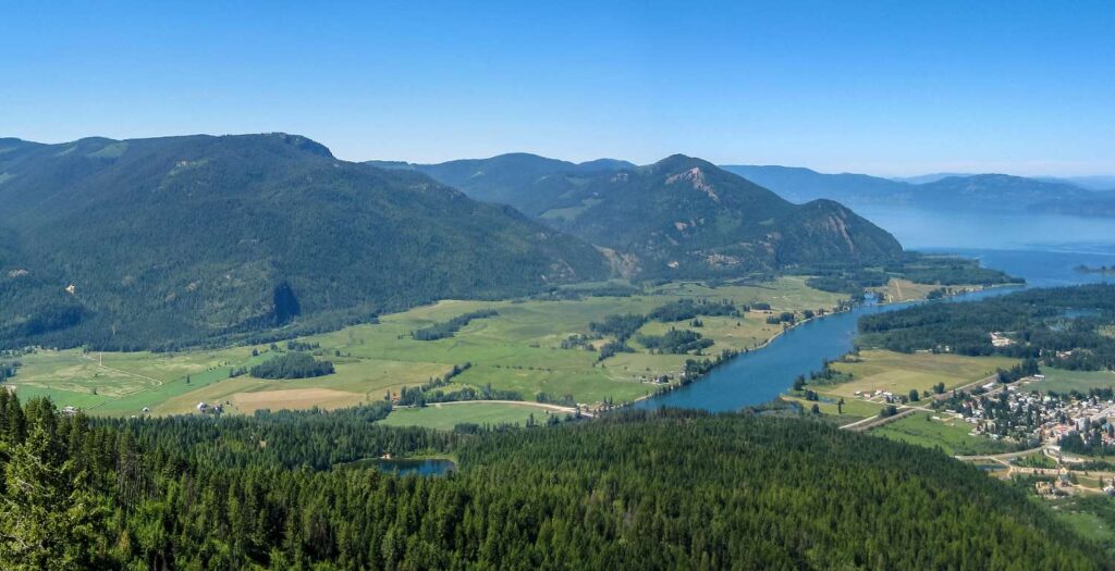
It is difficult to imagine that this peaceful and soothing spot where the Clark Fork River meets Lake Pend Oreille was ground zero for what is one of the planet’s most epic geologic cataclysms. The phenomenon is so difficult to imagine that even the scientific establishment did not accept it as fact for some 40 years after it was first theorized by geologist J Harlen Bretz in the 1920s.
Between about 15,000 and 13,000 years ago, during the last ice age, a massive lobe of ice flowing south from British Columbia along the Purcell Trench between the Selkirk and Cabinet Mountains filled the basin of Lake Pend Oreille and plugged the Clark Fork river valley, damming the flow of the Clark Fork River and creating an enormous lake known as Glacial Lake Missoula. With no outlet, the lake grew over decades, until the pressure of so much backed-up water actually lifted and cracked the glacial plug, resulting in a catastrophic flood that emptied the lake in a matter of days. The flood sent a volume of water ten times the combined flow of all rivers on Earth through Idaho, Washington and Oregon at highway speeds, scouring the land, depositing the sand and gravels of the Rathdrum aquifer, transforming the landscape across Washington state, and forming the Columbia River bar at the mouth of that river in the Pacific Ocean. The ice continued to flow in and plug the Clark Fork, repeating the cycle of lake fill and catastrophic flooding dozens of times until the ice age waned.
This is the epic story of regional geology that locals probably know best, but it’s not the only story waiting to be told.
Harlen Bretz’s original theory about the Glacial Lake Missoula Floods—or the Spokane Floods, as they are also known—was based on what he observed of the landscape in eastern Washington—giant ripple marks, sand bars, pot holes, cataracts and channels that seemed to indicate evidence of an enormous, fast-flowing river that washed across a broad area of eastern Washington and down the Columbia River valley. It seemed inconceivable, but that’s pretty much what happened. The problem was that nobody yet knew where all the water came from. It wasn’t until further research revealed evidence such as layers of lake sediments in areas of western Montana where no present lakes exist, and evidence of former lakeshores high up in the mountains of Montana and Idaho, that geologists came to realize there had once been an enormous lake that occupied a big chunk of western Montana. That, together with evidence of the Purcell lobe of continental ice that acted as a dam, provided the source of the floods.
There are several areas in and around Sandpoint where we can see evidence of the floods. Adjacent to U.S. Highway 2, a short drive west of Dover, there is a large sand and gravel pit that extends a significant distance up the flank of the mountains to the north. These sands and gravels were deposited when water from Glacial Lake Missoula came crashing down the Pend Oreille River valley. Many are familiar with an area further south, along Highway 95 just north of Athol (locals call it Granite Hill) where the road dips dramatically and cell phone coverage is marginal. That dip is the Hoodoo Channel, where some of the flood waters coming from the main outburst point at Bayview traveled across Farragut State Park towards Spirit Lake and then northward through the Hoodoo Valley into the Pend Oreille Valley. Flood deposits form the natural dam that created Spirit Lake, as well as other area lakes to the south, including Hayden and Coeur d’Alene. The flood deposits east of Spirit Lake exhibit giant ripple marks created by the flood current. Farragut State Park includes many features left by the floods and information about these is available at the Visitor Center. The Rathdrum aquifer, a primary source of water for the Spokane area, comprises a thick layer of sand a nd gravel deposited as flood waters made their way westward from Bayview across eastern Washington.
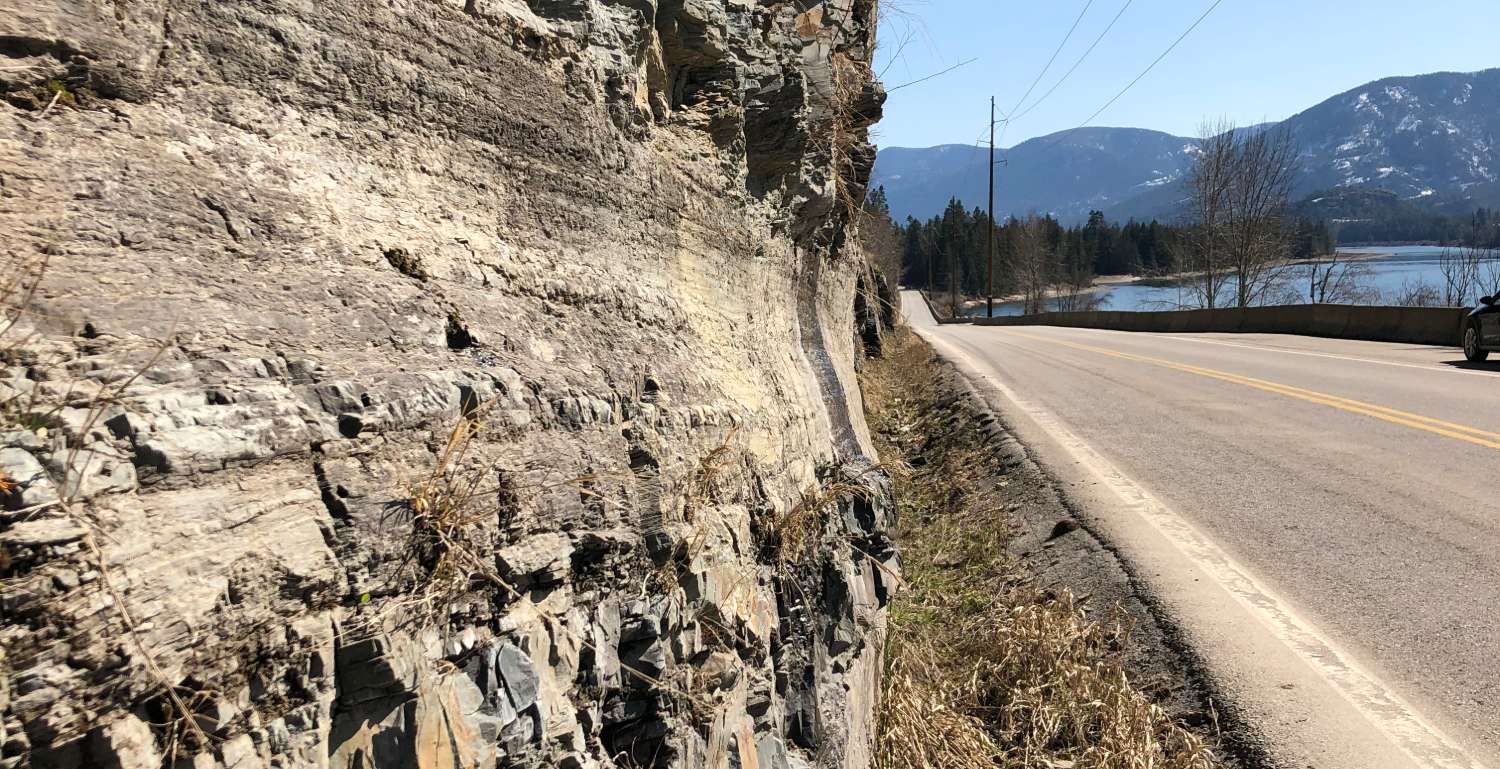
Glaciers gouged scratch marks into the rock that are visible today along Highway 200. Photo by Charles Mortensen
There are also good local examples of the continental glaciation that created Glacial Lake Missoula. If you take a walk at Pine Street Woods, for example, you’ll likely notice randomly strewn boulders and cobbles on the ground surface in the meadow. These are part of the glacial till—a jumble of rock, sand, silt and clay—that was dropped into place by the Purcell glacial lobe and now blankets the hill. A pond you might happen upon in a little hollow somewhere in the woods could very well be a depression created by a remnant piece of ice that melted in place as glacial meltwaters deposited outwash around it, and a huge boulder sitting incongruously in the middle of a field likely was dropped from the ice as continental glaciation retreated at the end of the ice age or was stuck in an iceberg carried with the waters from the epic floods. A short distance east of Clark Fork, a rock outcropping along Highway 200 was gouged by rocks entrained in glacial ice that held back the waters of Glacial Lake Missoula as it squeezed into the Clark Fork Valley, leaving a groove in the bedrock and scratches from the stones in the ice. On a good day, from a vantage point looking at the finger of the Bitterroot mountains that cradles the south side of the Clark Fork River, ancient strandlines, where the waves of the dammed lake crashed onto former shorelines, can be seen high up on the sides of the mountains.
As for Glacial Lake Missoula, Sandpoint residents are familiar with the notoriously poor-draining soil in their back yards that results from the dense clays just below the top soil. Those are lake bed sediments and they extend well north into the Selle Valley. One can imagine the boundaries of the lake expanding northward as the lobe of continental ice retreated at the end of the last ice age. Who knows, maybe the ice cantilevered over the lake bed and calved dramatically into the water in a dance of death.
What about the rocks and the mountains? Standing just about anywhere in Sandpoint or the Selle Valley to the north, one can look west to the Selkirk Mountains and east to the Cabinet Mountains on either side of the Purcell Trench, the long broad valley extending to the north that the ice lobe helped shape. The rocks of both ranges are very different, but they are closely related structurally and the Purcell trench is the linchpin.
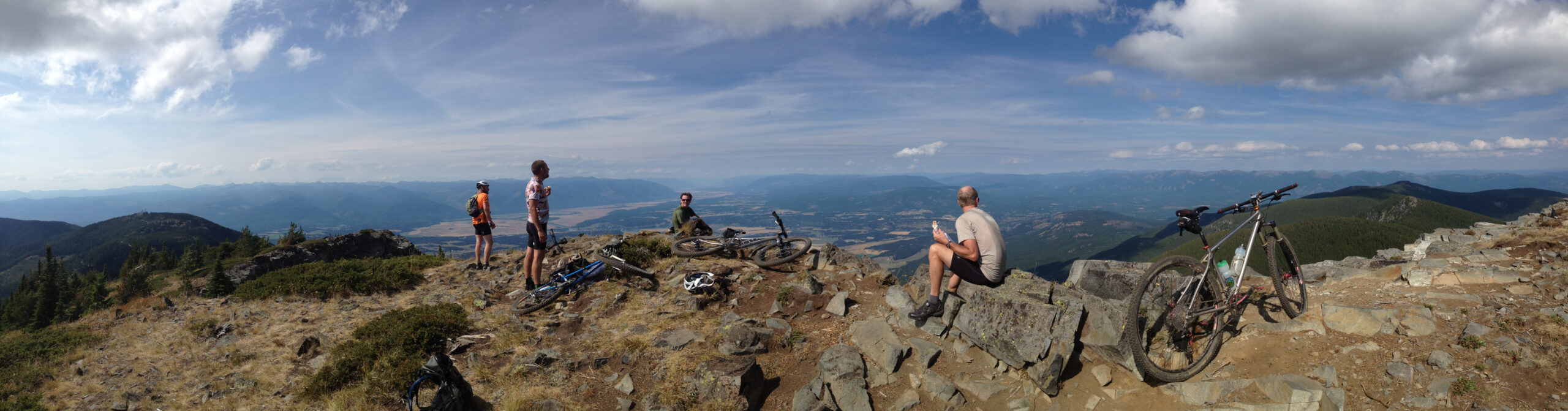
Bikes pause atop Clifty Peak overlooking the Purcell Trench. Photo by Charles Mortensen
The predominant rocks of the Cabinet Mountains comprise thick layers of sedimentary rocks altered by heat and pressure and known as the Belt formations, or the Belt Supergroup metasediments. These were deposited in shallow seas and lakes more than a billion years ago during Precambrian time. This was before animals evolved, so you won’t find fossils of critters in these rocks, but some exhibit well-preserved mud cracks and ripple marks, and others exhibit fossils of blue-green algae known as stromatolites. On the other side of the Trench, the Selkirk Mountains are predominantly made up of granite that rose as magma from the depths about 70 to 80 million years ago during the Cretaceous, when dinosaurs roamed the Earth. Rock climbers on Chimney Rock on the Selkirk Crest get great handholds on this granite and mountain bikers and hikers through Pine Street Woods or Syringa Heights will find themselves curling their way around knobs of younger Eocene granite as they find purchase on the glacial till that partially covers it. That granite formed a few million years after a giant meteorite killed off all the dinosaurs, except the birds. Metamorphic rocks—that is, rocks that have been utterly transformed from their original character by heat and pressure—are also present in the Selkirks. A beautiful exposure of these can be seen in large road cuts on U.S. Highway 2 between Sandpoint and Priest River, and hikers will encounter them on the Mickinnick Trail, just northeast of Sandpoint. Some of these rocks are more than 2.5 billion years old.
So, how did sediments deposited in a shallow sea billions of years ago end up as rock layers tilted at odd angles high up in the Cabinet Mountains, and how do they relate to the Selkirk Mountains and the Purcell Trench? It’s a long story. The origin of the metamorphic rocks like those we see in the roadcut between Sandpoint and Priest River is not firmly established, but given their old age it is reasonable to assume they represent what geologists call basement rocks. These are the rocks that formed before most other rocks we see on the planet, and they generally occur beneath other rocks we see at the surface. It’s likely that sediments that formed the Belt formations more than a billion years ago were eroded from these basement rocks during the creation of the basin in which the sediments accumulated. How this basin formed is unclear to geologists. Some believe it formed in an oceanic basin that widened slowly as the North American continent split apart; others hypothesize that it was created by a meteorite explosion that left a giant crater. Later, about 800 million years ago, the North American continent did split in the vicinity of Idaho’s western border via plate tectonics, carrying the western piece along with the likely source rock of the Belt sediments off to Siberia. Had humans been around then, they might have surfed off the beaches of Spokane.
A lot of time passed after all that, during which plate tectonics pieced together the Earth’s land masses into a supercontinent known as Pangea, and then promptly broke it all apart. Then, about 80 million years ago, the Pacific plate bashed into the western margin of North America, which was not too far west of present day Idaho, and dove under the North American plate, causing magma that became the granite of the Selkirk mountains—known to geologists as the Kaniksu Batholith—to rise through the existing rock during the formation of the Rocky Mountains. As the Selkirks rose, the granite lifted and cracked the overlying Belt formations, which slid off the eastern flank of the Selkirks and moved east along a fault, the Purcell Trench, forming the Cabinet Mountains. Yes, the rock of the Cabinet Mountains once rested on top of the rock that forms our portion of the Selkirk range.
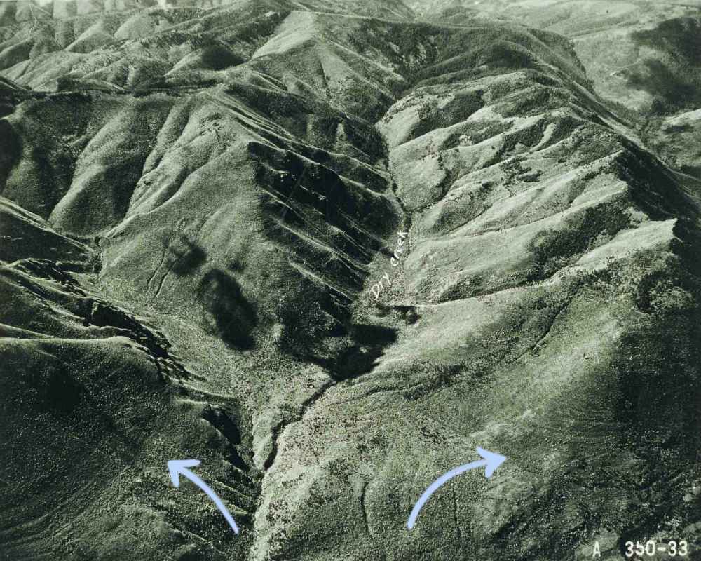
Ancient glacial lake Missoula mark the Bitterroot mountains just outside of Clark Fork U.S.F.S. Photo From the Corey Vogel Collection
Speaking of geologic faults, the one that created the Purcell Trench is certainly not the only one in the area. There are several that crisscross the trench and extend beneath Lake Pend Oreille and into the mountains. The Pack River Fault, which roughly parallels the river along its course out of the Selkirks and across Selle Valley, is one of several similar faults, the best known of which is perhaps the Hope Fault. The Hope Fault forms the abrupt topographical transition between the Clark Fork valley and the Cabinet Mountains in the area of Hope and Clark Fork and extends northward under the lake and into the Selkirk Mountains, where it, or one of its offshoots, weakened the granite, thus easing alpine glaciation’s erosional efforts in forming the basin that holds Fault Lake. Similarly, it’s no coincidence that the Pack River closely follows the Pack River Fault as it flows out of the Selkirks.
These faults are not necessarily related to the Purcell Trench fault that sent the Cabinet Mountains off to the east. Some geologists speculate that they may be a northern expression of ongoing continental extension caused by movement along the contact between the Pacific and North American plates which is slowly breaking apart the western U. S. It is thought that the deep basin of Lake Pend Oreille may be an expression of this extensional dynamic.
There is debate as to the age of all these faults but, for sure, at least some of them are still active. Active faults are where earthquakes come from and Sandpoint experienced a few memorable ones in 2015, the epicenters of which were somewhere beneath Lake Pend Oreille, likely along the Hope fault or an associated fault. There was no major damage, but lamps swung, chairs rocked, and a loud booming was heard in the east.
There are many stories in the local rocks and they are all epic beyond belief. The older ones developed over millions and billions of years and the latest chapter about the floods happened in the blink of a geologic eye. The result is a landscape that is beautiful beyond measure. And, while the stories are far beyond skin deep, their clues are there on the surface open to those curious enough to look for them during their wanderings along the lake and adventures in the mountains.
Charles Mortensen, owner of Sandpoint’s Syringa Cyclery, holds a master’s degree in geology.

Great synopsis! Thanks for writing this . Would you be available to discuss the tectonic history of the overriding North American plate and subducting Farallon plate sometime? Perhaps over a beer at Eichardts? I’m a retired geologist visiting from Oregon and would enjoy ‘talking shop’ about it (and I’ll buy ;-).
Always fun to tie geologic history with our home.
I recently found a fist size ( 599 gram) piece of pure black granite or…Carbonado;) that I assume was deposited during the Glacial Lake Missoula Floods since I have not observed any other black stone near by and this has been rolled/ polished in water.
Any feed back on this type of stone or references to further reading would be greatly appreciated.
I am working out of state but will definitely stop by the shop next time I am back home.
Great article. Thank you! I grew up in the Pan Handle. I am writing a book. I hope you can help me find the answers to: When did the Purcell Lobe of the Cordilleran Ice Sheet first form? How was Lake Pend Oreille formed. Keep up the good work.
Mark, the geologists Bruce Bjornstad and Gene Kiver have written on the Ice Age Floods impact in this region in their boook, “On the Trail of the Ice Age Floods: A geological field guide to northern Idaho and the Channeled Scabland”. You can see more about the book at our book publishing arm, Keokee Books. Here’s a link:
https://keokeebooks.com/products-page/regional-guide-books/a-geological-field-guide-to-northern-idaho-and-the-channeled-scabland/